The Romans
The Romans
The Roman era accompanies the entire route of the vacation road. The empire of the Roman emperors is present everywhere. They called themselves Imperators (rulers), Caesars (successors of Caesar) or Augusti (the exalted). The Danube (Danubius) formed the natural borderline, the Limes, of the Roman Empire to the north. There, in the "Barbaricum", lived free Germanic tribes. In contrast to the "walled limes", which met the Danube at Eining shortly before Kelheim, the Danubius was considered the "wet limes".
Like a string of pearls
Under Emperor Augustus, the Roman Danubian provinces of Raetia, Noricum and Pannonia were established shortly after the birth of Christ. Raetia comprised Upper and Lower Bavaria, Noricum the area of present-day Austria south of the Danubius. The Inn River formed the inner Roman customs border between these two provinces. Pannonia, which corresponds to today's Hungary on the right bank, adjoined to the east. Roman port cities and forts were strung along the Danube "limes" like a string of pearls. The majority of the cities along the Road of Emperors and Kings are of Roman origin. Regensburg (Castra Regina), Lorch (Lauriacum) near Enns and Carnuntum were ancient large cities with mighty defensive walls, temples, paved squares, theaters and arenas. Outside the fort walls, civilian settlements with markets and merchants' districts were formed, called "canabae" (from which comes the word "tavern") after the brothels and drinking establishments that were most commonly found there. Aquincum, today's Budapest, represented the largest city on the Roman Danube with over 20,000 inhabitants. Its luxurious thermal baths and hot baths were famous throughout the Roman Empire.
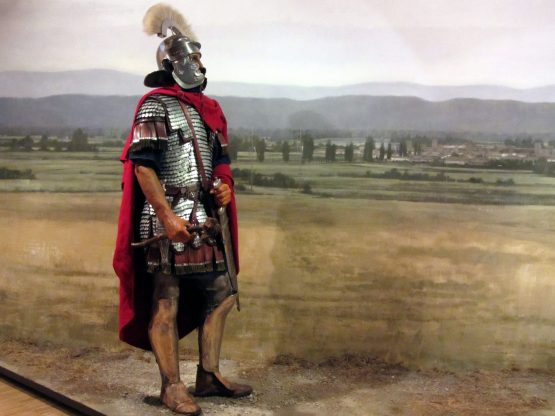
Enns Roman Museum © Huemer
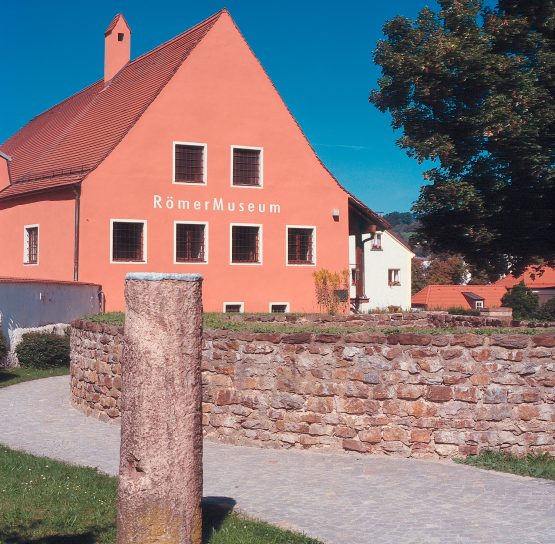
Roman department © Museum Quintana Künzing
The river border 'Ripa
The river border downstream was simply called Ripa (bank). This is where the Roman Danube fleet was active, which in imperial times had the ambition to have every mile of the river navigated by guard ships at least once a day. Fortresses and watchtowers rose on the banks of the Danube at precisely calculated intervals, enabling rapid communication between the crews. Some of these fortifications are still preserved. Signs along the road point to them - as to all historical sites. The extensive fortifications were not without reason, because the Germanic tribes north of the Danube were always on the move.
In the footsteps of Roman emperors
Under Emperor Caracalla (211-217) the continuous limes road along the entire Danube was completed. It represents, so to speak, the ancient precursor of the "Road of Emperors and Kings".
Those who want to follow in the footsteps of Roman emperors are right on the road of emperors and kings. Preserved buildings such as the Roman walls in Regensburg, Mautern, Tulln and Carnuntum await the visitor, archaeological sites such as those in Künzing, Lorch, Vienna and Budapest bring the forts back to life in the mind's eye and the modern museums in Künzing, Passau, Linz, Mautern and Petronell (Carnuntum) deepen these impressions.
Roman Museum © City of Passau
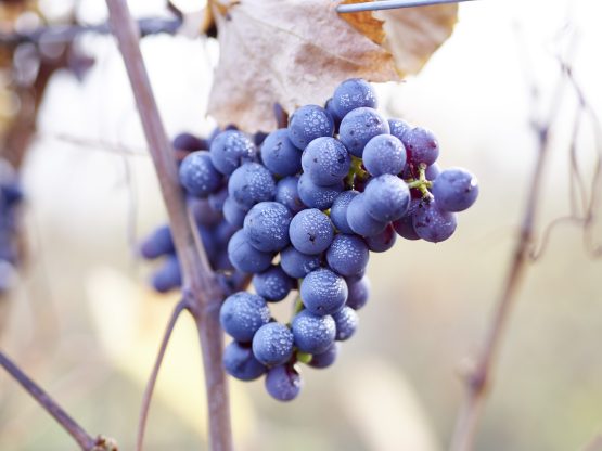
Winery Gmeiner © WGD Donau OÖ Peter Podpera
The Romans and the wine
And a legacy of Roman times flatters our eyes, nose and palate along the entire Danube Trail until it runs down our throats with relish: wine. In Roman times and in the Middle Ages, wine was cultivated throughout the Danube valley, including in Bavaria. A few small wine-growing areas east of Regensburg on the southern slopes near Donaustauf, Wörth and Wiesent still bear witness to this. They are based on Roman foundations and serve the "Baierwein". The Baierwein Museum in Bach on the Danube provides information about 2000 years of viticulture. The Wachau and the Vienna Basin, which are still among the classic vineyards, were more successful. Roman winegrowers probably created the Grüner Veltliner, the Viennese house- court- and country wine.
The Roman Transdanube Travel Story
As part of the Transdanube Travel Stories INTERREG project, a story entitled "The Danube Adventure - Legions on the Way to the Danubius - The River that Attracted Cultures" was written.
Impressions and route information from Regensburg to Serbia along the Danube can be seen and read here.
LEFT
German Limes Road
![]() The German Limes Road connects over 90 towns and communities, as well as numerous organizations. Travelers on the Limes Road pass through very different natural landscapes, just like on the over 1100 km long bike path, and encounter not only Roman monuments but also many sights from other eras. Since 2018, the German Limes Road also runs along the Danube Limes between Neustadt/Bad Gögging and Passau. Since then, the German Limes Road is also a member of the ARGE Road of Emperors and Kings and vice versa.
The German Limes Road connects over 90 towns and communities, as well as numerous organizations. Travelers on the Limes Road pass through very different natural landscapes, just like on the over 1100 km long bike path, and encounter not only Roman monuments but also many sights from other eras. Since 2018, the German Limes Road also runs along the Danube Limes between Neustadt/Bad Gögging and Passau. Since then, the German Limes Road is also a member of the ARGE Road of Emperors and Kings and vice versa.
Information material of the German Limes Road
The German Limes Cycle Route
The German Limes Hiking Trail
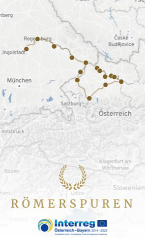
Roman Traces APPDiscover the Romans in Eastern Bavaria and Upper Austria with the Roman Traces APP.
15 sites from Neustadt an der Donau to Enns bear witness to the glorious Roman past of the Eastern Bavarian and Upper Austrian Danube region and are now brought to life for everyone in an app for iOS and Android. With the app, you can discover the exciting heritage of Rome in Eastern Bavaria and Upper Austria interactively and on site. With entertaining tasks, photo and audio stories, you collect Roman medallions as rewards and learn about the breathtaking history of the Roman sites along the Danube Limes. Successes can be shared from the app directly on Facebook & Co. Hopping" between the Roman sites is facilitated in the app by tourist information (accommodation, gastronomy) and supported by navigation (car, public transport, bike paths).


Worth seeing on the subject
Ferienstrassen.info (2)")


ferienstrassen.info")
ferienstrassen.info")

Museum Quintana Künzing")


ferienstraßen.info")


ferienstrassen.info")
ferienstrassen.info")


 Stadtgemeinde Hainburg")


Memory list for travel planning